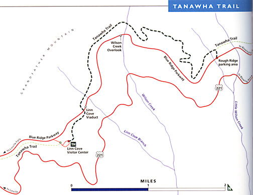
Tanawha Trail
Avery County, North Carolina
by Kevin Adams*
Reprinted from North Carolina's Best Wildflower Hikes: The Mountains, and used by permission.
Highlights: Great views from a wonderfully constructed trail
Trail Rating: Moderate
Trail Length: 2.6 miles each way
Location: Blue Ridge Parkway at Grandfather Mountain
Elevation: 4,320-4,680 feet
Contact: Blue Ridge Parkway; 828-271-4779
Bloom Season: March to October
Peak Bloom: Mid-June
Directions: The hike begins from Blue Ridge Parkway’s Linn Cove Visitor Center at mile 304.4; about 0.7 mile north from the parkway’s southern junction with US 221.
I had a tough time deciding on the "peak" wildflower bloom for this hike. In April the forest is alive with spring ephemerals, Catawba rhododendron puts on a show in late May and early June, and September brings out the asters and goldenrods. I doubt there is such a thing as the best time to make this hike for wildflower viewing, but I chose mid-June for the peak bloom of two species: mountain laurel and turkey beard. Mountain laurel is an abundant shrub but here on the rocky outcrops it creates a splendid foreground for the distant views. Turkey beard is such a unique wildflower and so uncommon, that it is worth hiking the trail just to see it.
Actually there are many reasons for hiking this trail, some having nothing to do with wildflowers. The trail passes directly under the well-known Linn Cove Viaduct on the Blue Ridge Parkway through (literally) the enormous boulders of Black Rock Cliffs, and finally down the spine of Rough Ridge, with incomparable views. The entire length of Tanawha Trail parallels the parkway and stretches some 13.5 miles from the visitor center to Julian Price Memorial Park, but the 2.6-mile portion that constitutes this hike is the most scenic section, and among the best hikes in North Carolina.
If you're not already familiar with the construction history of the Linn Cove Viaduct, spend some time at the visitor center before you make the hike; the volunteer attendants love to talk. The visitor center is open daily May-October, 9 a.m.-5 p.m. The gate is closed during the winter season, so if you come to see the April wildflowers you have to park back up on the shoulder of the parkway.
The hike begins as a paved, wheelchair-accessible path and soon passes through a seepage area, where water trickles from the ground over a wide area, saturating the soil. Seeps like this are always worth investigating. Among the profuse plant growth in mid-June are false hellebore and mountain meadow rue. Umbrella leaf is already in fruit, while coneflower, orange jewelweed, and bee balm have yet to flower. Come back here in August and you can also see the lovely, deep purple flowers of monk’s hood.
The real prize of the seepage area in June is the brick-red Gray's lily, a rare wildflower that is a candidate for federal listing as an endangered species. It grows only on a few of our mountain balds and in high-elevation, wet thickets, like this seepage.
Just past the seepage you come to an open area under the viaduct that has common fleabane and field hawkweed among the weedy growth. The paved path ends at a set of steps directly under the viaduct. The next 0.2 mile takes you past, over, under, and through the boulders of Black Rock Cliffs. Look out for Indian cucumber and galax along this stretch. Mountain laurel and Catawba rhododendron are common among the boulders. At a couple of points hikers have climbed out over the rocks overlooking the viaduct, but this practice is severely destructive to the fragile environment. Stay on the main trail.
Cross Linn Cove Branch on a footbridge at just under 0.4 mile. The trail now swings away from the viaduct and begins climbing through thick patches of galax. Mountain laurel grows densely along the trail, but you pass beneath the flowers and can't see them well. At 0.1 mile beyond Linn Cove Branch you come to a side path on the right that leads a few yards to a rocky, photogenic viewpoint of the viaduct.
The trail now goes on an undulating course through dense forest and over several branches. Not many wildflowers grow along this stretch in June, but you should see a few Jack-in-the-pulpit and galax. Reach an elaborate, arched footbridge over Wilson Creek at 1.2 miles. A side path just before the bridge leads down to the Wilson Creek Overlook on the parkway. Look to the right as you cross the bridge and you can easily see the parkway.
The rich woods in the vicinity of Wilson Creek are a good place to see spring wildflowers, but by mid-June just about everything is gone. I saw a few broad-leaved waterleaf on the right side of the trail just after crossing the creek but they were barely hanging on.
Two-tenths of a mile beyond Wilson Creek you pass beneath an enormous boulder outcrop and then begin a long climb through good spring wildflower habitat (only galax blooms here in mid-June). After a brief descent and a short set of steps, there is a white flowering shrub on the right side of the trail called wild raisin. You'll probably smell the fragrant blossoms before you see them.
A sign at 1.75 miles announces that you are entering a sensitive area with fragile soils. As you should have been all along, it is important to remain on the designated trail from this point forward. Just beyond the sign you pass through an especially rich area worth exploring throughout the season. Flowering on my June visit were
tassel rue,
mountain meadow rue,
meadow parsnip (mostly finished),
stinging nettle,
broad-leaved waterleaf (mostly finished),
false hellebore,
and several Gray's lily.
The foliage of several other wildflowers that bloom later in the summer was profuse at my visit, among them jewelweed, coneflower, and dodder — a bright orange parasitic vine that wraps around everything it touches.
The trail now climbs through patches of galax and speckled wood lily (displaying fruit in mid-June) and opens up onto Rough Ridge. Linn Cove Viaduct is plainly visible to the right, and Michaux's saxifrage grows all over the rocks on the left. Now climb a short distance to the peak ahead of you and a "T" intersection. To the right is a rock promontory and spectacular views. To the left is the continuation of Tanawha Trail.
Look around. You are standing in the middle of a typical heath bald natural community, in which most of the vegetation are members of the heath family. Mountain laurel is abundant, as is Catawba rhododendron, although the latter has mostly finished blooming by mid-June. Another heath member that grows here is sand myrtle. This low-growing, clumpy shrub resembles moss except for its white flowers. Blueberry shrubs, also in the heath family, are everywhere. They begin ripening in late June and make a July hike a tasty experience.
Rough Ridge is where you find turkey beard. Look for a tall stalk (up to 5 feet) supporting a raceme of small white flowers. Needlelike leaves grow in a dense tuft at the base of the stem, and short, grasslike leaves grow on the stern itself. Turkey beard is not common in the southern Appalachians, occurring only in dry, open, and usually rocky environments like here on Rough Ridge. Once you've seen it for the first time you'll always recognize it, even from a distance.
The steel cables on Rough Ridge are intended to keep people on the designated trail so they don't trample the fragile environment. While the cables may create problems for photographers using wide-angle lenses, you can see everything you need to see from the trail.
From the "T" intersection the trail descends steeply through the dense heath vegetation to a lower viewing area with boardwalks and viewing platforms. Even if you didn't see another person before you got to Rough Ridge, you'll likely have to share the views here. At less than 0.3 mile from the Rough Ridge parking area, this is an extremely popular destination. Although mid-June is a good time for wildflowers, my favorite time to be here is in autumn when the blueberry foliage turns bright red.
After what you've seen to this point, the remaining 0.3 mile from the boardwalk is anticlimactic. Right after you cross over Little Wilson Creek on another arched footbridge, you come to a spur on the right that leads a few yards to the Rough Ridge parking area on the parkway. If you didn't leave a second vehicle or arrange a shuttle, you must either backtrack or follow the parkway back to the visitor center. Foot traffic is prohibited on the Linn Cove Viaduct, so if you walk along the parkway you'll have to exit it at the start of the viaduct and scramble through the woods a short distance to pick up the Tanawha Trail.
* Acclaimed photographer and North Carolina native Kevin Adams is the author of North Carolina Waterfalls, Wildflowers of the Southern Appalachians (with coauthor Marty Casstevens), Waterfalls of Virginia and West Virginia, Hiking Great Smoky Mountains National Park, Our North Carolina, North Carolina Then & Now, Backroads of North Carolina, and North Carolina's Best Wildflower Hikes.